Photograph img_0963.jpg

Junction of Hill Farm Road and Hitcham Road


Map of location 65 Location 58 Location 59 Location 90 Location 60 Location 91 Location 61 Location 72 Location 76 Location 62 Location 71 Location 75 Location 73 Location 92 Location 74 Location 70 Location 93 Location 63 Location 69 Location 64 Location 68 Location 65 Location 66 Location 67

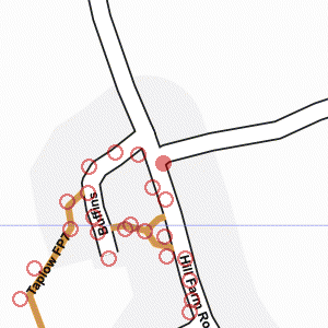
Photograph taken 2002-04-21

Looking South on Hill Farm Road. Trees and bus stop on the left. Houses on the right. Parked cars.

Looking North on Hill Farm Road.
Wire fence around allotments on the left.
Hedges both sides of road.
National speed limit sign. Looking East on Hitcham Lane.
Hedges both sides of road.
National speed-limit signs.
House behind hedge on right.
Trees in the distance.
Telephone wires. Looking South on Hill Farm Road.
Trees and bus stop on the left.
Houses on the right.
Parked cars. Church Cottages.
Cottages built from sandy-coloured brick with inset decoration in red brick.
Looking West into Buffins.
Trees and grass area on the left.
Street light and parked cars.
Large trees in the distance. Church Cottages.
Row of cottages built from sandy-coloured bricks with decoration in red brick.
Diamond-leaded windows.
Date AD 1853 set into wall in red brick.
Gardens with grass and low shrubs. Looking North on Hill Farm Road. Junctions with Buffins on the left and Hitcham Lane on the right.
Allotment gardens on the left.


Creative Commons License
All images are © Andrew Findlay 2002-2007 and licensed under a Creative Commons Attribution-Share Alike 3.0 License.

Some Rights Reserved Maps are derived from OpenStreetMap data, licenced under the Creative Commons Attribution Share-Alike 2.0 licence.